Here at Turtler GPS LTD we’re working hard to build the best application for travelers to share locations with their loved ones, friends and audiences. We are focusing on two types of location sharing: live location sharing and static location sharing.
Sharing live locations answers the age-old question: “where are you?”, and facilitates meet-ups, keeps us connected to loved ones for our safety, and can be used creatively for example publicly broadcasting an adventure live to an audience.
For people such as travel bloggers, sharing the fixed, static locations of places they’ve visited and recommend to their audiences is also a powerful tool. Ideally, they can share simple map links so their readers can find (or avoid!) the specific place they’ve raved about. Many adventurers explore the world using wild trails. And it is important to get the right off-road GPS, but some of them can simply use a map and still be on track. So, what do travel bloggers prefer to use in their trips?
We’ve asked 26 top travel bloggers their thoughts and preferences on current map and GPS apps and this is some of the enlightening feedback we received and learned a lot from:
Google Maps currently takes the cake
As we see Google Maps is by far the most popular mapping app for pro travel bloggers. The ubiquity of the Android OS, the general omnipresence of Google, the staggering depth of data in their Google Maps, and assumed ease of use certainly make them a default or first choice for many.

Multiple bloggers cite however that there are many UX issues with Google Maps, with some features like pinning locations, naming them and sharing them being frustrating to use. Google’s ‘data hunger’ and data collection priorities keep insisting the app connect online can get in the way of an easy experience for users on the go without super strong internet connections.
Simpler, more narrowly focused apps like Maps.me and Sygic Travel can prevail for the power user who can’t abide by Google Maps or default Apple Maps complications.
In their own words
Our survey results indicate only 69% of professional travel bloggers are happy with current map and GPS app options.
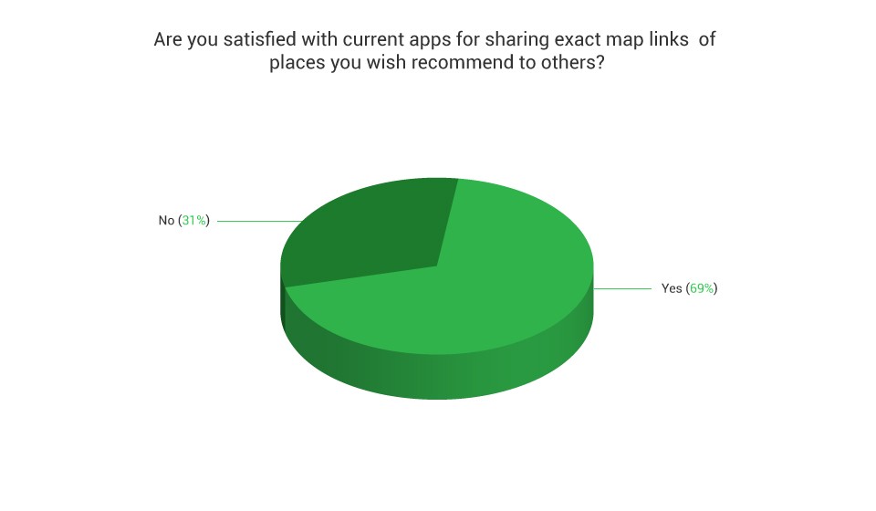
At Turtler, this confirms our belief that better solutions for pinning (or ‘bookmarking’ in Turtler-speak), making notes on, adding images to, and sharing locations are possible. Not to mention the sharing of live locations which is clunky in current apps and a data privacy nightmare when tacked on to leading social media services, but that’s another story…
Our questions:
- What is your preferred mapping and/or GPS app for travelling and sharing and why?
- What are the failures among the apps you've tried?
- What do map and GPS apps need to do better?
- What features are missing for you?

Mar from “Once in a Lifetime Journey”: “I use Google My Maps. It is easy, it is accessible to everyone and it has all the content from Google Maps. I wish I was able to add text to the map so it appears alongside the pins and show on the map.” Mar is a long term expat and travel influencer who helps brands with their digital marketing strategy. Her career spans digital advertising at Google, management consulting for multinational telecom operators across the world and short periods at JPMorgan, Tyco and PwC.

Andrew and Emily from “Along Dusty Roads”: “Google Maps and Instagram Stories. We use Google Maps for tracking where we have been for reference later and also for planning our routes. It's offline function is excellent for any city breaks or road trips as well, with the GPS still working perfectly over our saved maps. We also use Instagram Stories for sharing locations with our readers whilst travelling, for example using the location tag alongside a video or photo. Google Maps doesn't make it easy to bespoke a map in the way that we'd like, and to include as many bespoke notes or features as we'd like to. An app that could help you personalize a route or a country map without too much difficulty would be an excellent addition.” Along Dusty Roads is one of the UK's leading travel blogs. Personally created and curated by Andrew and Emily, it focuses on helping people to travel more and to travel better.

Helen from “My Faces and Places”: “Google maps - it is credible and reliable. It is widely used and most people understand it. Accessibility and reliability are needed. When you are lost - you want to get the right information. When you are sharing, you want reliable information.” The "My Faces and Places" blog is aimed at the matured travellers who are discerning in their choice and enjoy comfort with luxury - soft adventure, culture, heritage, arts and cuisines of the world.

Jonny from “Don`t Stop Living”: “Physical map - hate GPS or using phones for it. You need to have electric, battery, Wi-Fi, GPS etc. Just bring a paper map - much easier. All features are missing. Physical map wins.” Jonny is a perpetual tourist, backpacking touring Northern Irishman, struggling with depression and coping with liars.

Shannon from “A little Adrift”: “I use Maps.me if I am somewhere pretty remote, and Google Maps otherwise. I like the combination of maps and reviews offered on Google Maps, but Maps.me sometimes has non-traditional routes and roads that are good for bicycling around the backroads of a small town in Vietnam, or things of that nature. There's a customization missing for me on Google Maps. I can star places, or create a custom MyMap, but that's about it. There's nothing in between. Right now I have dozens of stars for all of these places I have visited, but I have to click around trying to find that one restaurant I loved and share that — everything I enjoyed from markets to pubs to cafes are all just little yellow stars.” Shannon is a travel writer blogging about responsible tourism and on the road since 2008.

Richelle from “Adventures Around Asia”: “I'm most familiar with Apple Maps because Google Maps is blocked in China. I typically take a screenshot of Apple Maps and share it as a JPEG. I'd love an app that makes it easier to share locations or your route. I'm also interested in apps where I can make my route after the fact so that I can share it with people. It would be so great if I could "check in" at places I traveled to, and then embed a map in a blog post where people can zoom in and click on the locations. That would be a dream for a travel blogger.”

Nellie from “Wild Junket”: “Google Maps works best for me, as I can easily located a place and share that with friends who are heading to the same destination. I also love to use Google Maps to pin out my itinerary and then share that with my travel partners. I think the main disadvantage of most map and GPS apps is offline capability. Most of them don't work offline and that's a major issue as many of us don't have internet access when traveling, especially in less-accessible and remote parts of the world.” Nellie is a professional travel blogger and writer, founder of adventure travel blog WildJunket.com. She has traveled to over 120 countries on all 7 continents and has a special interest in extreme destinations and family adventures.

Jennifer Dombrowski and Tim Davis from “Luxe Adventure Traveler”: “Our preferred app for traveling and sharing places on our site is Google Maps. Google Maps is quite accurate for navigation, includes public transportation options and has an offline option. We also plug in our destination to track we're headed in the right direction when we use services like Uber, as a safety precaution. We create custom Google Maps that we embed on our blog, Luxe Adventure Traveler. It's easy for our readers to use the map with a click, without the need to plug the information into another map app. The one thing we wish Google Maps did a bit better is listing public transportation options. We often find that it will tell us that there isn't public transportation available, but that isn't true. Also, the times for buses, trams and such aren't always correct so it's always best to download a local public transportation app to plan journeys.” Jennifer Dombrowski and Tim Davis are the professional travel writers and photographers behind the award-winning travel blog Luxe Adventure Traveler. They love adventure and wine, often combining the two. If you’re looking for a travel blog about a long-term around-the-world journey, how to travel on $50 a day or less or traveling with kids, Luxe Adventure Traveler isn’t it. Their award-winning travel blog is all about heart pumping adventures, world class accommodations and luxury experiences.

Annette from “Bucket List Journey”: “I use the Google Maps App because I like to be able to pinpoint all the attractions of a city under one folder. This makes it so much easier to find them and what other attractions are nearby. The struggles for me have always been getting the GPS map to work well offline. There are so many destinations that I travel to where there is no cell service or internet access.” Annette is the author of Bucket List Adventures, co-owner of Sugo Trattoria, a serial adventurer and creator of the award winning travel and lifestyle blog, Bucket List Journey.

Gary from “Everything Everywhere”: “I use Google Maps, but it is too busy when displaying on a website.”

“Maps.me is my favorite mapping app. I like it because it is based on Open Street Map Project, which is crowd sourced, so anyone who participates can add places or make corrections. I find it to be much more accurate than Google Maps, with many more places included. Also, once the app is installed, country maps can be downloaded to the local drive, which means they use the device’s built-in GPS to function - no WiFi or cellular data is required. I live in Thailand, so I’ve had the choice between Grab and Uber for taxis. Uber has much better mapping services than Grab, but in my experience is more expensive. Unfortunately, Uber just two days ago [March, 2018] announced that they’ve sold all their operations in SE Asia to Grab, so it remains to be seen if they start using Uber’s better mapping service,”- says Barbara from “Hole In The Donut”.

“Um… Probably showing map details in blog posts. Texting people exact locations as well for places. I use Google Maps,”- says Dave from “Jones Around The World”.

David from “Love Adventures”: “By Road (online): Google Maps for its functionality, ease of use and extensive data / information. By road (off line): Maps.Me for its offline capability and extensive POI index that is user influenced. On foot (UK): OS Maps, for good access to OS Mapping, GPS positioning, rout creation and augmented reality.On foot (international): Either View Ranger or MotionX-GPS for access to mapping layers from multiple other sources and services. The biggest fundamental missing feature in all mapping apps on the market is the ability to download offline mapping (specifically and importantly the satellite layers - that are already free/open source) for use on more remote international expeditions. A satellite layer adds so much more contextual data, but without having to use data, which may be expensive when abroad, yet can still be used with GPS positioning on the device.” David Love is a British adventurer, mountaineer and expedition leader. He's also a Commissioned Officer in the British Army and survival instructor with the Bear Grylls Survival Academy. He's undertaken numerous expeditions across the world, both by land and sea, and travelled to some of the most volatile countries on earth, including Afghanistan, North and South Sudan, Somalia, Libya, Mali and other swathes of Sub-Saharan Africa and the Middle East. But his true passion is rooted in the hills and mountains of the Great Britain, where he spends much of his time working with young people in some of the country’s most challenging environments with the aim of inspiring the next generation to discover their own spirit of adventure.

“I use Google Maps, as it's easy to use, intuitive, and can be easily integrated into web pages. It's often quite difficult to find places I want to pinpoint on a map. I have to do a lot of searching into a particular place or landmark's alternative name (as per the map). Also when I map a route (taking in several stops) and I veer off that route, I lose the facility to rejoin it unless I have wifi/data signal,”- says Kiara from “Gallop Around The Globe”. Kiara is a UK-based traveller, writer and photographer.

Bram from “Travel.Experience.Live.”: “I currently use Google Maps.” Bram was born and raised in Flanders, Belgium. He lives in Virginia where he spends his days exploring the Blue Ridge Mountains, writing and practicing photography. His blog focuses on national parks, outdoor adventures (specifically hiking and camping) and landscape photography.

“I use Google Maps, Yelp and Apple Maps. That's a good question. I think that the difference in information between each map makes it frustrating. Google maps has information that Apple maps doesn't have, and vice versa. I like that Apple maps integrates Yelp reviews, it makes for a better experience when you have as much information as possible in one location, instead of having to switch between different apps,”- says Meelad and Cassie from “Exsplore”. Exsplore is an adventure travel blog based in California that's dedicated to providing nature lovers with the best stories possible.

Becky from “Global Grasshopper”: “I use Google maps as it's very easy to access and straightforward to use. I think it would be good to have suggestions of great nearby places that would be of interest to you.” Becky is a semi-nomadic traveller, but otherwise the UK-based owner of Global Grasshopper – an award winning blog and resource for independent travellers. She is embarking on a journey to unravel the secrets of the world's most unique, under-the-radar and beautiful places.

“I normally use Google maps but it isn't great. Sometimes it is just totally wrong. Especially in some of the places I visit which can be quite remote. It's also not that easy to plan walking routes. Also sometimes it is really really slow to load,”- says Claire from “Clarie`s Itchy Feet”. Claire is a full-time traveler and Digital Nomad. At 34 she sold all her worldly possessions that wouldn’t fit into 3 boxes or her backpack and hit the road.

“Currently I only use Google Maps! I'd love to exactly pin-point a location and tell readers the best way to get there! Possibly even a route which highlights the best sights on the way!”- says Lavina from “Continent Hop”. Lavina is a full-time Analyst. She loves travelling and loves trying to find out ways to balance the both in the best way possible. She loves her profile and travel helps keep her creative and happy.

“Google Maps, because it's the one most people are familiar with and it usually has the most information about local businesses. Crowdsourced information like that on Google Maps is never perfect. Lots of listings are out of date or not quite accurate. Also, there are a lot of locations that you can't download offline maps for (such as Bangkok) which is something I always try to do before visiting a new place in case I don't have connectivity all the time.Then, of course, there's the fact that nothing from Google works in China,”- says Matt from “XpatMatt”. Matt is a professional travel blogger and photographer and own a digital marketing agency for travel brands. So, he travels a LOT.

Megan from “Mapping Megan”: “I use Google Maps. Ability to function offline is needed.” Megan is an Australian Journalist who has been travelling and blogging since 2007, with the main aim of inspiring others to embark on their own worldwide adventure. Her husband Mike is an American travel photographer, and together they have made the world their home. Committed to bringing you the best in adventure travel from all around the globe, there is no mountain too high, and no fete too extreme! They haven’t been everywhere, but it’s on their list.

JB and Renée are the Traveleaters behind Will Fly for Food, a travel blog for the gastronomically inclined. They use Sygic Travel: “Sygic Travel is our preferred travel planning app. It helps us to more easily plan our trips and navigate between points of interest. Sygic Travel is a great app though the map could be better. It doesn’t recognize minor points of interest like smaller restaurants so I need to manually pin the locations myself. Another inconvenience is that it doesn’t allow you to put multiple cities on one trip. For example, if you’re visiting five cities on one trip, then you’ll need to create five itineraries. It would be nice to do it all on one map and itinerary. If Sygic Travel could allow you to do multi-city trips and locate points of interest as easily and effectively as Google Maps, then I think it would be the perfect travel planning and navigation app.”

Aiden from “Freeborn Aiden” shared a story with us about GPS being inaccurate and illogical: “Well one time in Oslo Google Maps announced "Destination is on your right". It was indeed on my right but about 200 metres below me - the app had led me up a footbridge and seemed to be suggesting that I throw myself of it!”

Dev from “FootLoose Dev”: “I use Google maps. I think it's easy to use, fast to load and has maps for pretty much every corner in the world. Google maps even words perfectly in some of the least developed countries. I recommend Google Maps to everyone. I think if Google maps can add a functionality where a user can track the location of the other person, it would be perfect. This can take tracking and security to the next level.” Dev started blogging in January 2016, and in just 2 years he has worked with nearly 50 travel companies/tourism board in Europe, Australia and Asia. Moreover he has been featured in two leading Indian newspapers, namely The Economic Times and The Statesman.
Alesha and Jarryd, the award-winning writers, professional photographers and influencers behind Australia's biggest adventure travel blog, NOMADasaurus. "We use Maps.me - love that the maps are available offline, and there's a huge range of attractions and locations on there. Google Maps - love the ability to check public transport options."
Lina & David Stock from "Divergent Travelers": "As professional travelers, we've been to more than 80 countries on 6 continents highlighting the best experiences you can have along the way. Currently we use Polar Steps to track our trips. Auto tracking that actually works when you start moving would be great. Currently, the apps require that you 'start' each trip, and that is annoying if you forget. You should be able to set a home point and any time you leave the designated radius of that area, it should begin tracking."
According to our research, this is a summary the most common failures of the apps and features which need to be improved:
- Adding text into bookmarks.
- Personalizing a route with less difficulty.
- Accessibility and reliability. When you are lost - you want to get the right information. When you are sharing, you want reliable information.
- Showing map details in blog posts. Texting people exact locations as well for places.
- The ability to download offline mapping (specifically and importantly the satellite layers - that are already free/open source) for use on more remote international expeditions.
- To have suggestions of nearby places.
- Difficult to pinpoint on the map.
- Every GPS and map app has different information. For instance, Google maps and Apple maps have different data.
- Speed of loading is low.
- Maps are inaccurate.
- To make location sharing and to embed a map in a blog post easier.
- To automatize auto tracking (to start working when you start moving, instead of clicking “start”).
- Necessity of ability to function offline.
- Better map displaying on a website.
- Better listing of transportation options.
And there you have it! Map and GPS apps have a long way to go to achieve fully frustration-free user experiences. Hopefully Turtler will help!


Share this article